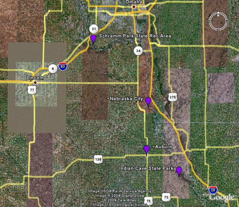
Late Paleozoic rocks in Nebraska are often covered by the younger (Pleistocene), tan-colored loess and the overlying vegetation. Pennsylvanian-Permian strata, however, are visible in a few localities. The map of Nebraska below indicates a few locations where rock outcrops of this age can be visited.
This park is located off of I-80 at Exit 432 (the exit for Gretna), between Lincoln and Omaha. Schramm Park is approximately 6 miles south of the freeway, along the nothern bank of the Platte River. Pennsylvanian-aged limestones and shales of the Lansing Group (more specifically the Vilas and Stanton formations) can be observed. Fossils of fusulinids, crinoids, and rugose corals can be found (click HERE to learn more about these fossils). The cyclic geology is well described at the outcrop which has been deemed a "Geologic Display". Two disconformities (or time gaps within the rock sequence) occur - one is between the Pennsylvanian and Cretaceous rocks near the top of the outcrop; the other occurs between the Cretaceous and overlying Pleistocene loess.
For more information on Schramm Park, visit HERE
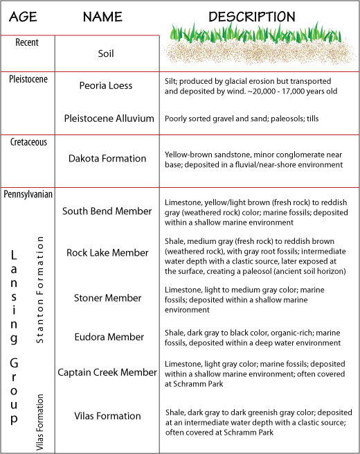 |
The image to the left is a stratigraphic column of the rocks that can be seen at Schramm Park. |
Just outside of Nebraska City - where the Hwy 2 crosses the Missouri River, the Pennsylvanian Waubansee Group can be seen forming cliffs. Brachiopods, fusulinids, and crinoids can be found in these limestones (click HERE to learn more about these fossils).
In the vicinity of Auburn - roadcuts expose the Permian bedrock (Admire & Council Grove groups) .
Indian Cave State Park is located ~10 miles south of Brownville, Nebraska and west of the Missouri River. The geology at this location includes a large channel sandstone deposit that cuts into the underlying, older rock strata. This downcutting was produced by fluctuating sea level. Pennsylvanian-age coal deposits also occur within the park, indicating that at one time, this area was a swampy environment. A coal seam 18" to 30" thick was mined during the late 1800s; however, it is not extensive enough to actually mine for profit.
For more information on Indian Cave State Park, visit HERE
 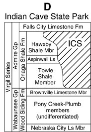 |
The image on the left is a stratigraphic log for the geologic units which can be observed within Indian Cave State Park. (from Fischbein et al., 2009) |
.gif) |
The image at the left is the Indian Cave Sandstone. |
The following were referenced on this webpage:
Fischbein, S.A., Joeckel, R.M., and Fielding, C.R., 2009, Fluvial-estuarine reinterpretation of large, isolated sandstone bodies in epicontinental cyclothems, Upper Pennsylvanian, northern Midcontinent, USA, and their significance for understanding late Paleozoic sea-level fluctuations, in Sedimentary Geology v.216, p.15-28.
Maher, H.D., Engelmann, G.F., and Shuster, R.D., 2003, Roadside Geology of Nebraska, Mountain Press Publishing Company, 264p.