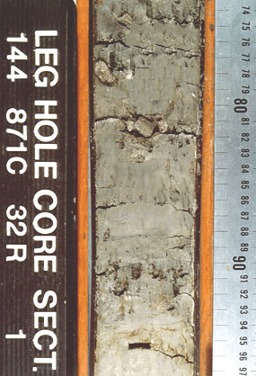
ODP
Leg 144
ODP Legs 143 and
144 set out to investigate the nature and geologic history of atolls and guyots
("gee' oh"; "g" is hard, as in "guy").
|
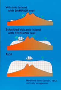
Charles Darwin was the first
to hypothesize that volcanic islands, atolls, and their varying types
of reefs all had a common origin:
- islands were formed by
the buildup of repeated lava flows from volcanoes; these islands have
barrier reefs
- volcanoes became quiescent
and began sinking; these islands have fringing reefs with a lagoon
between the ocean and the island
- when the volcano sank
completely, all that remained near sea level was the fringing reef,
which is now an atoll.
Later, the reef-forming animals
of the atoll may die off, and the whole structure sinks below sea level.
It is planed off, possibly by wave erosion, and forms an undersea, flat-topped
mountain called a guyot. |
 |
The flat top of guyots suggested
that they had been deeply eroded by waves as they slowly subsided below sea
level. Consequently, no one expected that any record of the terrestrial, subaerial
history of the guyot would be preserved. But paleosols,
ancient soils, were recovered below shallow-water carbonates (the reef) and
above highly weathered basalt (the volcanic lava flows) during Leg 144. These
ancient soils hold a record of the terrestrial history of the volcanic island
as it formed and while it slowly subsdided below sea level.
Better seismic data from Limalok
Guyot in the Marshall Islands indicate the flat top of this guyot is the result
of a thick cap of pelagic ooze, especially nannofossil ooze. Beneath the cap
are shallow-water calcareous (limestone) deposits of the reef, and beneath these,
29 m of weathered basalt and paleosol were recovered atop less-weathered basaltic
lava flows.
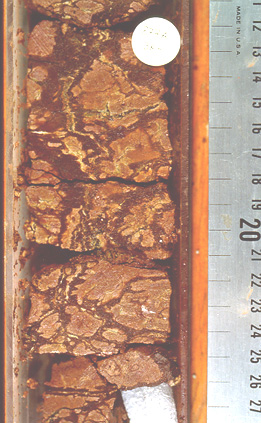
Of the 29 m of weathered material,
at least 13.0 m comprised a single paleosol.
|
The upper meter is kaolinitic
clay. At the very top there are calcite fossils of shallow
marine organisms, marine organic matter, and pyrite with a marine sulfur
isotope signature. After the soil sank below sea level, the marine waters
of the lagoon became anoxic, and reduced the upper part of the paleosol.
The black color diminshes
in intensity with depth as organic matter and pyrite levels decline, taking
a sharp drop at about 94 cm in this core.
|
 |
|
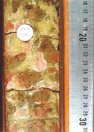
The next NINE meters of
paleosol comprise strong redoxomorphic features,
or mottling. Mottles are composed
of khaki goethite (FeOOH), lurid red hematite, and pale green to white
kaolinite. These features indicate alternate wetting and drying. During
wet phases, bacteria in the soil consume all of the oxygen, causing the
Eh to drop below 0; reducing conditions.
Under reducing conditions,
iron is reduced to its ferrous (Fe2+) mobile form. The iron moves (segregates)
to concentrate in some areas, leaving iron-depleted zones behind.
When the water level drops
again after days to weeks of no rain and ongoing plant transpiration,
oxygenated air from the soil surface can once again move into the pore
space of the soil, causing oxidation of the iron.
The more wet/dry cycles
occur, the more iron segregation can occur, and the more intensely mottled
the soil will become.
|
 |
|
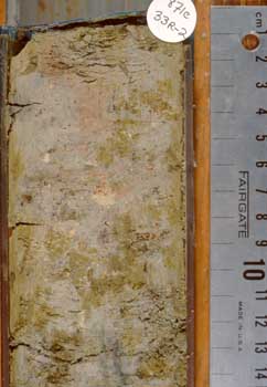
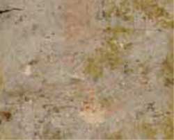
Below the redoxomorphic
zone is a 3-meter thick pallid zone.
Here, the colors are paler, and overall the section is lower in iron than
the overlying redoxomorphic zone.
Such a thick (9 m) redoxomorphic
zone overlying a pallid zone, suggests that rather than water levels fluctuating
over 13 m several times a year, probably the water table lowered as soil
formation proceeded. If the groundwater level fluctuated only a meter
or so, but declined over time over the 9+ m, a thick redoxomorphic zone
could form.
When streams eroded downward
through the landscape and intersected the level of what would become the
pallid zone, water flowed laterally out of the bottom of the soil profile
and into the stream, taking much of the iron with it and leaving behind
the pallid zone. Later submergence of the soil profile allowed alteration
of some of the remaining iron to siderite (FeCO3), outlined when you move
the cursor over the image at right.
|
 |
|
An earlier stage of redoxomorphic
conditions occurs at Site 873 on Wodejebato Guyot. LEss iron has been
leached from between the iron-enriched zones.
Less of the upper part of
the soil was preserved here, as the site was closer to the outer edge
of the guyot, and probably experienced more wave erosion than the centrally-located
Limalok Guyot site (Site 871).
|
 |
|
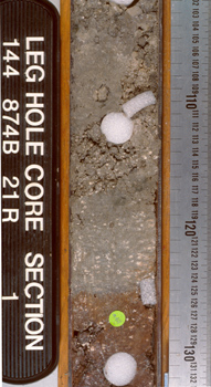
The most striking example
of how submergence of the island and deposition of lagoonal sediment caused
reduction of these iron-rich paleosols occurs at Site 874B on Wodejebato
Guyot.
This material is classic
C horizon palesol: it looks just like the basalt it altered from, but
is composed entirely of kaolinite and smectite, with the paleo-vesicles
infilled with vermiform kaolinite (white specks in both gray and red zones).
|
 |
|
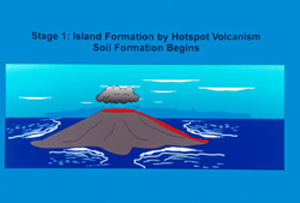
The sequence of development
of the strongly redoximorphic paleosols on the Pacific guyots, Limalok
and Wodejebato, may have proceeded like this:
1) A volcanic island formed
over a hotspot as repeated lava flows built up the volcanic edifice from
the seafloor, until the edifice breached the sea surface.
Big Island of Hawaii is
a good example of this.
|
 |
 |
|
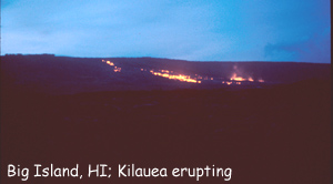
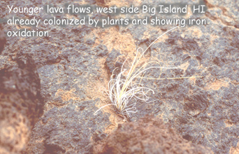
2) Almost as soon as the
lava flows breacehed the sea surface, and proceeding until the island
drifted off of the hot spot and became quiescent (no more volcanic activity),
plants colonized the island, rain fell, and soil formation began.
The younger flows of Big
Island of Hawaii are a good example of this.
|
 |
 |
|
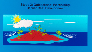
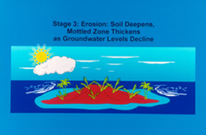
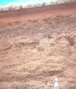
3) As weathering proceeds,
the soil deepens. Erosion lowers the level of the island, causing groundwater
levels to drop, and the redoxomorphic zone deepens.
Although not mottled, the
soils in central Oahu, Hawaii (right image), are very thick.
|
 |
 |
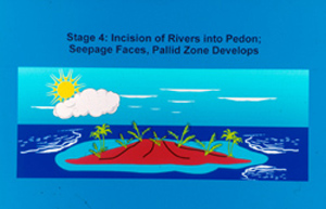
| 4) Erosion proceeds
to the depth of what is now the pallid zone of the Limalok Guyot paleosol.
Water can move freely laterally, at the base of the soil, to the streams.
This moving water takes the mobile iron with it, forming the pallid zone
at the base of the soil (Macfarlane, 1976). |
 |
 |
|
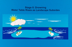
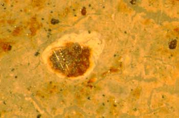
5) Water levels rise again,
upward from the base of the soil profile, as the island submerges. Siderite
forms in the pallid zone.
At right, a thin section
from the pallid zone showing siderite coating an iron glaebule.
|
 |
 |
|
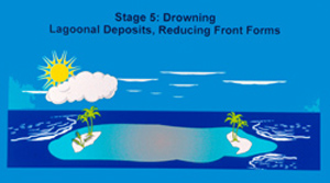
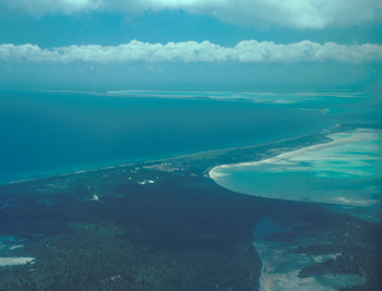
6) Lagoonal deposits form
on top of what is left of the soil (almost certainly the very tops were
eroded during submergence), forming the reduced zone that migrated downward
into the soil profile from above.
At right, Christmas Island
of the Pacific is a modern atoll. Roll mouse over the image to see the
lagaoon.
|
 |
 |
Ocean
Drilling Program Leg 141 Scientific Results
Holmes,
M.A. 1995. Pedogenic Alteration of Basalts Recovered During Leg 144. Proc. ODP,
Sci. Results, 144: 381-398.
Buchardt, B.,
and Holmes, M. A, 1995. The Initial Transgressive Phase of Leg 144 Guyots: Evidence
of Extreme Sulfate Reduction. Proc. ODP, Sci. Results, 144: 895-913.
Holmes' Research
Page
Holmes'
Home Page