The Cenozoic Timescale and Paleogeography


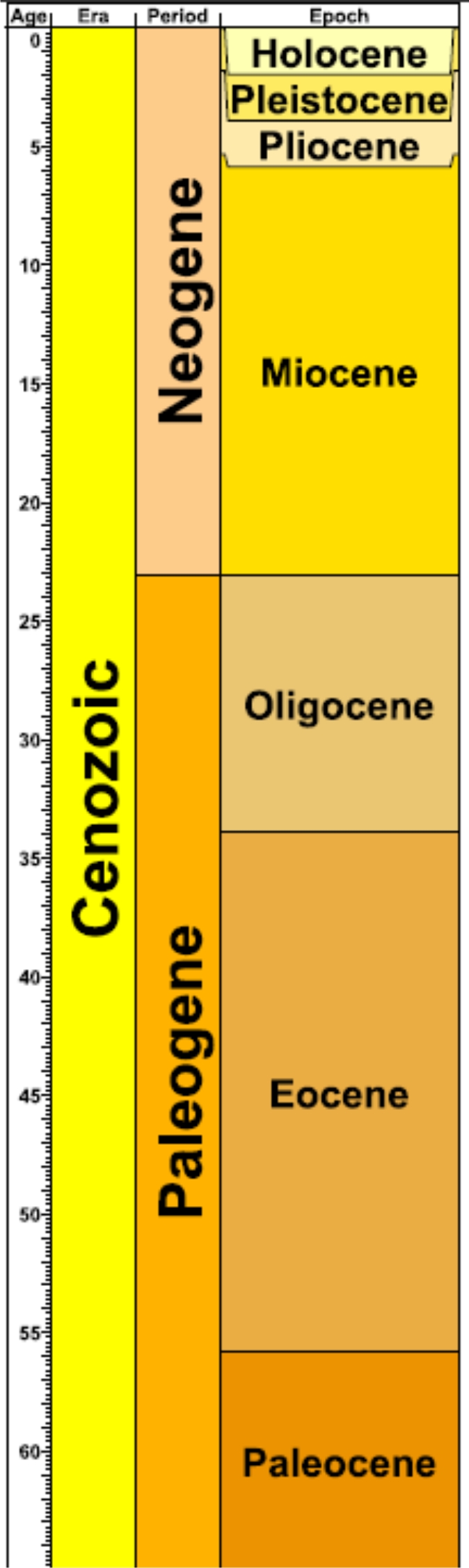
This chart at the left shows the subdivisions of the Cenozoic Era. The Cenozoic spans an interval of time from 65 million years ago until the present. The era is divided into two periods, the Paleogene and the Neogene. These, in turn, are subdivided into shorter intervals of time called epochs. Click on epoch names to learn about Nebraska during those times. The timescale was generated by Timescale Creator (http://www.stratigraphy.org).


Information about global-scale events that occurred during the Cenozoic may be found at the sites below:

http://www.palaeos.com/Cenozoic/Cenozoic.htm

http://anthropology.si.edu/humanorigins/faq/gt/cenozoic/cenozoic.htm

Paleogeography and Climate

Paleocene Epoch

55.8 - 65.5 million years ago

This map shows how North America appeared 60 million years ago. Earth's climate was warm relative to today. Polar ice sheets were smaller and sea level was higher. The climate in Nebraska was warm and humid, and the Rocky Mountains were forming in the western part of North America.


Eocene Epoch

33.9 - 55.8 million years ago

This map shows how North America appeared 50 million years ago. Earth's climate was warm relative to today. Polar ice sheets were smaller and sea level was higher. The climate in Nebraska was warm and humid, but began to cool and become more arid toward the end of the epoch Eocene. To the west, the Rocky Mountains continued to form. Sediment shed from the uplifting mountains was carried eastward by river systems and deposited in Nebraska.


Oligocene Epoch

23.0 - 33.9 million years ago

This map shows how North America appeared 25 million years ago. Nebraska supported a vast savannah-like environment, and climate was cooler and drier than during the Paleocene and Eocene Epochs. Sediment from the uplifting Rocky Mountains continued to be shed across Nebraska.


Miocene Epoch

5.3 - 23.0 million years ago

This map shows how North America appeared 18 million years ago. River systems in the Rocky Mountains continued to carry erosional sediments to Nebraska during the Miocene. The climate was cool and dry compared to the tropical Paleocene and Eocene Epochs. Towards the end of the Miocene, the global climate became even cooler and drier because of an expansion of glacial ice sheets on Antarctica.


Pliocene Epoch

1.8 - 5.3 million years ago

This map shows how North America appeared 3 million years ago. Global sea level dropped over 50 meters in the Pliocene because of an increase in glacial ice at the poles. This increase of glacial ice created a global climate that was relatively dry and cool. At the end of the Pliocene, further expansion of glacial ice occurred at the poles, which led to another decrease in global temperatures, and a drop in sea level around the world.


Quaternary (Pleistocene)

0.01 - 1.8 million years ago

This map shows how North America appeared just over 12,000 years ago. During the Pleistocene, repeated glaciations occurred, some of which covered parts of eastern Nebraska. This was the time period that many people have labeled the "Ice Age." The glacial ice that advanced from northern Canada created many of the features we see on the landscape today, such as the Great Lakes.


Present

This is how North America appears today. All of the features we see on the landscape today (i.e. mountains, rivers, valleys) are the result of geological processes that have been occurring continuously for millions of years.

The Cenozoic paleogeographic maps of North America above are from Dr. Ron Blakey- http://jan.ucc.nau.edu/~rcb7/ ), which are based on observations and interpretations from the geologic record. Click HERE to visit Dr. Blakey's website to learn more about paleogeography and how the continents have changed position throughout geologic time.

Back to Cenozoic Home Page